OpenAthena™ for iOS
OpenAthena for iOS
An iOS port of the OpenAthena project
OpenAthena™ allows consumer and professional drones to spot precise geodetic locations.
?️?? + ?⛰️ = ??


Get it in the Apple App Store (coming soon)
Operation Guide
Obtain a GeoTIFF Digital Elevation Model:
To use this app, you need a GeoTIFF Digital Elevation Model (DEM) file. GeoTIFF files store terrain elevation data for an area on Earth. OpenAthena performs a ray-cast from a drone camera’s position and orientation towards the terrain, which can be used to precisely locate any point within a given picture.
To obtain a GeoTIFF file for a certain area, use this link.
Unfortunately, the NGA tiff library for iOS does not support tiff compression. Consequently, DEMs should be obtained using Method 1 from the above web link. Method one makes use of Open Topography SRTM elevation data
If you try to load an elevation model containing TIFF compression, the application will crash. Currently, its not possible to intercept this crash (in Swift parlance, catch the exception) because the app is written in Swift and the library is written in Objective-C.
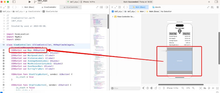
Load a GeoTIFF Digital Elevation Model ⛰:
Load the DEM file (e.g. cobb.tiff) using the “⛰” button. The app will display the size of the file and its latitude and longitude boundaries:
(NOTE: during file selection, the thumbnail image preview for any GeoTIFF “.tiff” file will be blank. This is normal.)
Calibrate your drone’s compass sensor ? and take photos :
It is strongly suggested that you should calibrate the drone’s compass sensor for the local environment before taking photos to be used with OpenAthena. Consult your drone’s operation manual for this procedure. The image metadata from an un-calibrated drone can be several degrees off from the correct heading. This can result in dramatic target-resolution inaccuracies if the sensor is not calibrated. Always verify a target match location from OpenAthena before use!
Select an Image ?:
This app is compatible with images taken by select models of DJI, Skydio, Autel, and Parrot aircraft models. The drone’s position and its camera’s orientation are automatically extracted from the image metadata.
After loading a GeoTIFF DEM, use the “?” button to select a drone image containing the necessary metadata:
Calculate a target ? ?:
Press the “?” button to calculate the target location on the ground. You can tap the result display box to copy the result text to your clipboard or open the position in Google Maps by clicking the blue hyperlink:
Application Settings (optional) ⚙:
OpenAthena for iOS supports multiple output modes for target calculation, including:
- Latitude, Longitude (standard WGS84)
- Nato Military Grid Reference System (MGRS) 1m, 10m, and 100m
- CK-42 Система координат Latitude Longitude (an alternative geodetic system commonly used in slavic countries)
- CK-42 Система координат Gauss-Krüger Grid: Northing, Easting (an alternative military grid reference system used by former Warsaw pact countries)
To change the ouptut mode of OpenAthena for iOS, tap the kebab menu icon (three dots) at the top-right corner of the main screen and select “Settings”:
Select your desired output mode by pressing its button in the list and then click the Save button.

Contributing
UI language translation
If you speak another language in addition to English, please consider contributing to the UI translation using the link below. The insights of a native-speaker are the only way to provide a good user experience for the program in a given language:
https://www.transifex.com/thetalimited/openathena-for-ios/
Code
If you’re interested in contributing to this project, feel free to make a fork. This project will follow the fork and pull model for third-party contributors